Those familiar with the OSINT community will know the name OSINT Curious. Before the project closed, it ran a popular series called Ten Minute Tips — short, practical tutorials designed to teach geolocation and open source investigation skills to beginners.
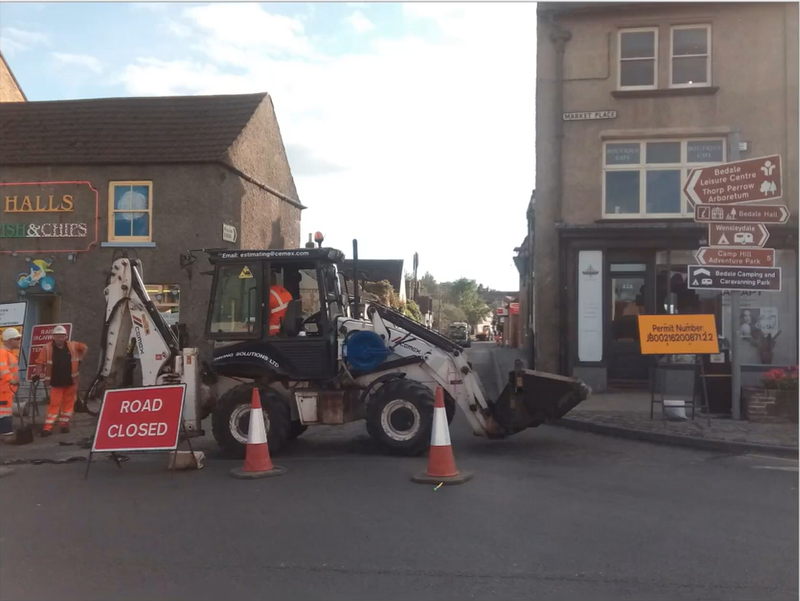
One of their most referenced exercises involved a single street photograph, and the goal was simple: figure out exactly where it was taken.
The method they used worked. But if you go back and read it, you will notice it takes you through Boolean searches, cross-referencing multiple data points, and a layered research process that feels far more complicated than the problem actually requires.
For a beginner sitting down to learn geolocation for the first time, that level of complexity can be more discouraging than helpful.
This is the same exercise, done the simpler way. Same image, same answer, far fewer steps.
Extracting Information
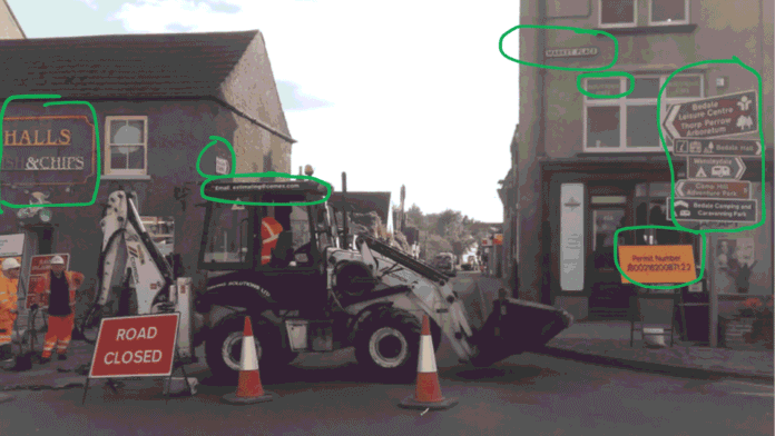
Before doing anything else, slow down and look at the image carefully. Treat every visible detail as a potential clue and write down everything you can see. Here is what this image gives us:
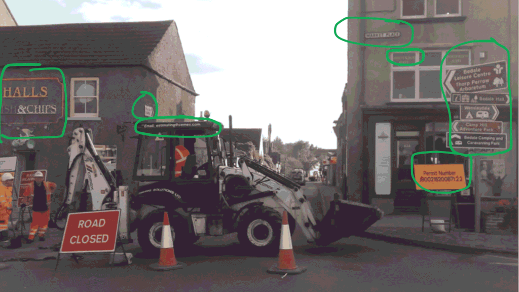
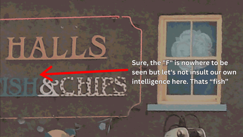
- Sign: “Halls Ish and Chips” — probably Fish and Chips
- Cyclist picture on front of house
- Flag in the window — white flower emblem
- Road sign: “Masham B6268”
- Green truck and yellow digger in the background
- Red and white signs — one possibly says “SOLD”
- White digger with “Cemex” logo
- Email address: estimating@cemex.com
- Multiple roadworks signs
- Pennants in the window — same as the flag in the upper window
- Roadworks permit number
- Street name: “Market Place”
- Sign: “Boutique Cafe”
- Number: 42A
- Sign: “Bedale Leisure Centre”
- Sign: “Thorp Perrow Arboretum”
- Sign: “Bedale Hall”
- Sign: “Wensleydale”
- Sign: “Camp Hill Adventure Park”
- Sign: “Bedale Camping and Caravanning Park”
Without falling into any bias or assumptions, we can say with complete confidence that the single most important and directly searchable piece of information in this entire list is number one. The name of that shop is all we need.
The Easiest Way
Here is the thing about geolocation that beginners are rarely told upfront. When an image contains a business name, that business name is almost always the fastest route to the answer.
Open Google. Type “Halls Fish and Chips Bedale” (since we know Bedale is a place) and hit search.
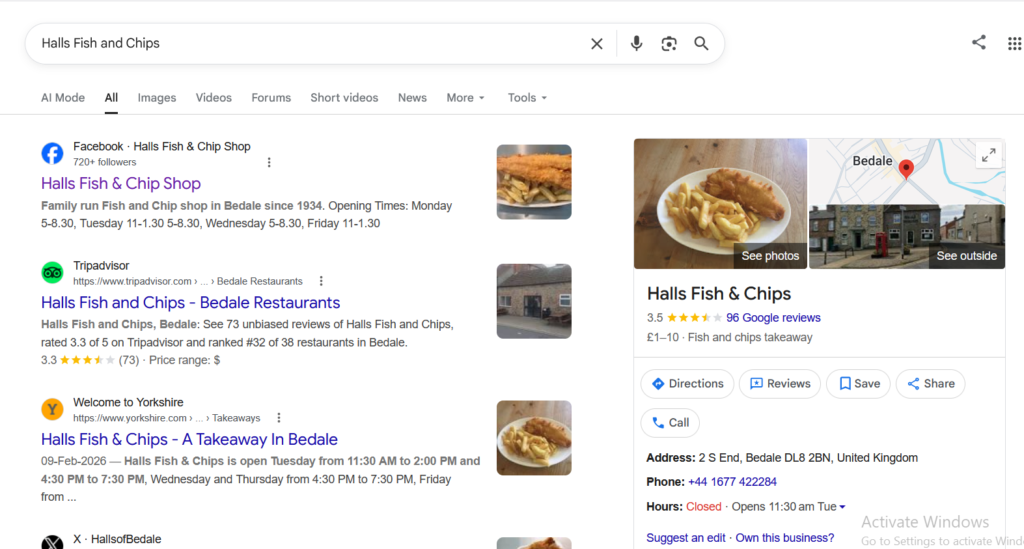
That is it. Within seconds Google returns the exact location, a map pin, reviews, photos, and a street address. No Boolean searches, no cross-referencing arboretums, no methodical elimination of data points.
The most obvious piece of information in the image, the name of the shop on the sign, leads directly to the answer in one search.
This is the principle that the OSINT Curious tutorial buried under several layers of methodology: start with the most specific and searchable piece of information you have, and try the direct route first. If the direct route works, you are done. Save the complex methodology for the cases where the obvious approach genuinely fails.
In this case, the obvious approach works perfectly. Halls Fish and Chips, Market Place, Bedale, North Yorkshire, England.
Finding the Exact Location
Now that we know the town, the street, and the business, the final step is confirming the exact spot where the photograph was taken and matching it against the image in front of us.
When you search the business name on Google, a map appears directly in the results. Click on it and Google Maps opens with a pin dropped on the location. From here, click the Street View option and drag yourself right onto Market Place outside Halls Fish and Chips.
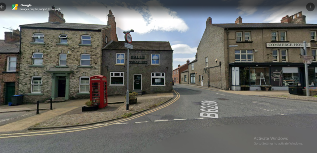
What you are looking at on your screen is the same street, the same buildings, the same layout that appears in the original photograph. The road signs match. The building numbers match. The Boutique Cafe visible in the background of the original image is right there on Street View.
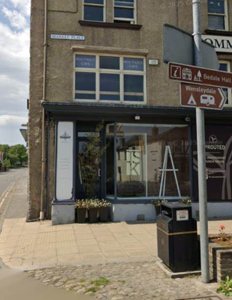
The only differences are the roadworks, which were a temporary feature present when the original photo was taken but naturally absent from Google’s Street View imagery captured at a different time.
That is your verification done. The image was taken on Market Place in Bedale, North Yorkshire, standing outside or near Halls Fish and Chips, looking toward the town centre.
From a single business name visible on a partially obscured sign, to a confirmed exact location on Google Street View, in three steps and under five minutes.
Conclusion
The OSINT Curious methodology was thorough and taught valuable habits around systematic extraction and verification. Those habits matter enormously when you are dealing with images that contain no obvious searchable text. But when the information is right there in the frame, the best investigators are also the ones who know when to keep it simple.
Extract everything. Try the obvious route first. Verify with Street View. That is the whole process.
Like us on Facebook, follow us on Instagram and TikTok, and subscribe on YouTube for more stories from the world of espionage and OSINT.